Kaikōura earthquake generated huge submarine sediment shift

The 2016 Kaikōura Earthquake has shown that more than 100 million dumptrucks of mud and sand flow through the Kaikōura Canyon every 140 years, scientists say.
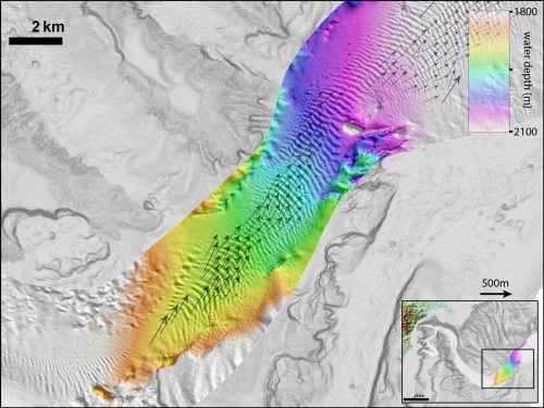
Pre and post earthquake morphology of the lower canyon gravel waves. [Images: Dr Joshu Mountjoy, NIWA]
In a paper published today in noted scientific journal Science Advances, lead author NIWA marine geologist Dr Joshu Mountjoy, says the earthquake triggered one of the largest “canyon flushing” events ever documented. Canyon flushing is an event in which high energy currents transport sediment from canyons to the deep ocean.
The paper also reveals the extraordinary impact this event had on the canyon and what was living in it at the time of the 7.8MW quake.
The sediment, calculated by scientists to be at least 850 million tonnes, billowed down from the head of the canyon, through its central channel, wiping out all organisms living in the seabed.
It then travelled along the deep sea Hikurangi Channel and its banks, where scientists took samples of the sediment-flow deposits, known as turbidites, up to 680km northeast of Kaikōura .
Dr Mountjoy said in 2013 everything at the head of the canyon was smooth and draped in mud but investigations two months after the 2016 earthquake revealed that the mud from almost every part of the upper slope had been stripped away.
“The event has completely changed much of the canyon floor, eroding into rock and moving dunes of gravel through the lower canyon,” Dr Mountjoy says.
“We knew that events like this could happen from telecommunication cable breaks during earthquakes that can cause major interuptions to international communication. However, we have never had data to show us what impact these events have on the canyons themselves.”
The paper reveals that the floor of the two main reaches of the Kaikōura Canyon have deepened by up to 50m. In the middle-canyon region, depressions in the bedrock floor have deepened by 20-30m.
Dr Mountjoy says that the impact has been extreme and is the long-term process that shapes submarine canyons.
The results indicate that submarine canyons can cut their way into rock much faster than previously thought with the study providing the first direct evidence of the impacts of a full canyon-flushing event.
Similar events are calculated to reoccur on average every 140 years, triggered by large earthquakes.
“This study unequivocally demonstrates that earthquake-triggered canyon flushing is the primary process that carves out submarine canyons and delivers coastal sediment to the deep ocean.”
The material removed included seven million tonnes of carbon that is now available to nourish deep sea communities. A NIWA study in September last year found that the former biodiversity hotspot decimated by the earthquake, is now showing signs of recovery with evidence of juvenile animals that once dominated the head of the canyon beginning to colonise the seafloor.
Other studies since the earthquake have revealed it was the most complex quake ever recorded, rupturing more than 21 on and offshore faults along more than 100km, producing widespread coastal uplift, vertical ground movement and numerous landslides.
This study was part of a collaboration between NIWA, Victoria University of Wellington, GNS Science and international colleagues funded by the Natural Hazards Research Platform.
Disclaimers and Copyright
While every endeavour has been taken by the East Coast Lab Hikurangi Subduction Zone M9 to ensure that the information on this website is
accurate and up to date, East Coast Lab Hikurangi Subduction Zone M9 shall not be liable for any loss suffered through the use, directly or indirectly, of information on this website. Information contained has been assembled in good faith.
Some of the information available in this site is from the New Zealand Public domain and supplied by relevant
government agencies. East Coast Lab Hikurangi Subduction Zone M9 cannot accept any liability for its accuracy or content.
Portions of the information and material on this site, including data, pages, documents, online
graphics and images are protected by copyright, unless specifically notified to the contrary. Externally sourced
information or material is copyright to the respective provider.
© East Coast Lab Hikurangi Subduction Zone M9 - www.eastcoastlab.org.nz / +64 6 835 9200 / info@eastcoastlab.org.nz
